Getting Started with 2D
Overview
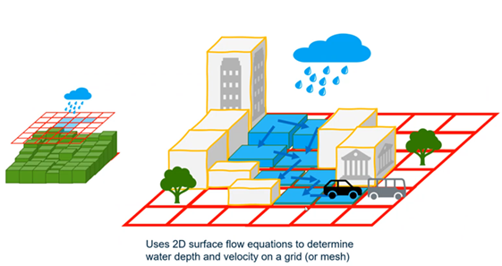
This version of the software enables coupled 1D/2D simulations. This means that the 1D system elements (e.g., inlets, manholes, conduits, channels, ponds, catchments) are able to interact with the 2D surface by exchanging flow and depth information.
Gutters on the 2D grid are ignored when running the coupled 1D/2D simulation. Instead, flow to the inlet is determined by the 2D surface characteristics.
Calculation Options
To run a coupled 1D/2D simulation, set the Active Numerical Solver to 2D Solver in the Calculation Options.
- Rainfall on Catchments Only means that the grid will only receive flow from other model elements, such as catch basin overflows. 1D Catchment elements would be used for hydrologic calculations.
- Rainfall on Grid and Catchments means that the grid itself can receive rainfall, and rainfall on 1D catchments (if present) will be computed as well. Care should be taken to avoid overlapping catchment areas with the grid, as this would result in double-counting these areas for runoff generation.
2D Modeling Workflow
You need to define a Computational Grid for the 2D Solver to use when calculating.
Here are the steps to define a computational grid:
- Choose a terrain model to define the starting elevations of the surface (View > Terrain Models).
- Layout a Grid element to specify the area of interest (the area where the user wants to analyze surface flooding).
- Refine (or adjust) the computational grid using Grid Adjustment Layers and/or Grid Adjustment Elements (e.g., define where buildings, roads, grassy areas, etc. are).
- Generate the Computational Grid.
Use the Grid Browser to review the resulting Computational Grid and repeat steps 3 and 4 until satisfied.