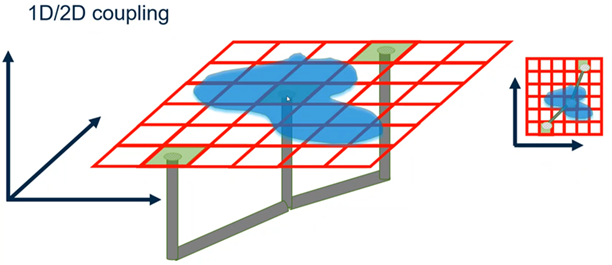
Simply placing 1D nodes such
as outfalls, unbolted manholes, inlets atop a grid will couple the element to
exchange flow with the corresponding grid cell. The ponds and rivers are also
simulated as 1D elements, thus grid cells intercepted by ponds and rivers are
voided (burned-in to the grid). Flow and water elevation information is
exchanged by the 1D and 2D engines through automatically generated interfaces.
Coupling of a pond (polygon) or river (cross sections and channel links) with
the grid becomes more obvious when you perform a Generate Grid.
2D Surface
Elevation Matching: A grid cell has its Elevation assigned
interpolating its cell center point against the active terrain model. When
placing a Catch Basin atop the grid cell the user must chose to have the cell
elevation by set to the rim elevation, or vice versa, with the 2D Surface
Elevation Matching attribute. For a perched or depressed inlet, select Adjust
Grid to Rim.
2D Reporting
Point: Add a Reporting Point (2D Modeling
tab >
Reporting Point) to any location on the grid
where you want to generate more detailed 2D output. After you Compute, you can
right click -> Graph to view time-series of 2D results (I.e. Plot of depth
on grid.) at those points.