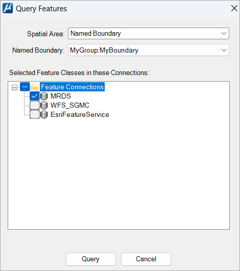
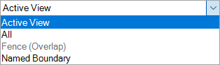
| Spatial Area
|
Displays the possible values given below:
- Active
View: Only the feature instances that are inside or are overlapping
the extent of the active view will be queried.
- All: All the
feature instances of the selected feature classes are queried without any
limited area.
- Fence
(Overlap): This option is only available when there is an active
fence. The software will use the fence as if its mode were
Overlap regardless of its actual mode.
- Named
Boundary: The area to use is defined by a
Named Boundary. The limit to use must be
selected in the Named Boundary right below the
Spatial Area field.
|
| Named Boundary
|
Available only when the option
Named Boundary is selected to define the
spatial area. All the Named Boundaries available in the master model and their
references are listed in the drop-down.
|
| Selected Feature Classes in these Connections
|
Lists all the open connections available in the active model. You
must select the connections you want to query from. The feature classes to
query in these connections must be chosen beforehand using the
Edit feature connection tool.
|
| Query
|
Queries all the feature instances that are inside the area as
well as those that overlap it.
|
| Cancel
|
Closes the window without saving the changes made in the Query
Features tool setting window.
|
 Used to specify the parameters
you want to use to query.
Used to specify the parameters
you want to use to query.