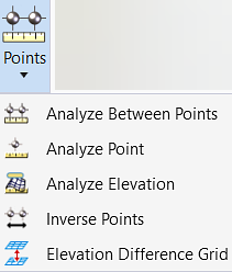
Analyze Between Points
 Used to review elevation, slope,
distance and delta information between two selected points of a terrain model
or mesh.
Used to review elevation, slope,
distance and delta information between two selected points of a terrain model
or mesh.
You can access this tool from the following:
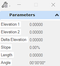
Use the Analyze Between Points tool to review elevation, slope, distance and delta information between two selected points of a terrain model or mesh.
Workflow
1. Start the tool.
2. Select the terrain model.
3. Datapoint the first point. If the point is outside the terrain model or inside a void, it is not a valid point and therefore not accepted. Another point must be selected.
4. Datapoint the second point. (Use the ALT keyboard button if second point is on a different terrain model.)
5. Distance, slope and delta elevation are reported between the points.
|
Settings |
Description |
|
Elevation 1 |
Elevation in master units of the terrain model or mesh at the X, Y coordinates of the first selected point. |
|
Elevation 2 |
Elevation in master units of the terrain model or mesh at the X, Y coordinates of the second selected point. |
|
Delta Elevation |
Elevation difference (in master units) between elevation 1 and elevation 2. |
|
Slope |
reports the slope of a line between point 1 and point 2 based on the X,Y coordinates of the two points and their respective terrain elevations. It does not take into account the terrain slopes between the two points. |
|
Length |
reports the length of the line between the two points. |
|
Angle |
reports the direction of a line between point 1 and point 2 based on the X,Y coordinates of the two points. |