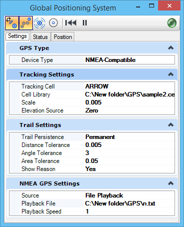
| Settings tab |
The Settings tab specifies settings needed by the Global Positioning System interface. |
| Status tab |
(Available only for NMEA-Compatible and Garmin USB device types) The Status tab displays a graphical representation of the GPS satellites within reception range, their sky position, and signal strength. |
| Position tab |
The Position tab displays the position the GPS device is calculating from the signals it receives. |
| Track |
Displays the specified cell at the geographic location within the current model. Since the location within the model can be determined only if there is a geographic coordinate system defined for the model, the tool is disabled if there is no GCS.
GPS
TRACK
Note: This tool must be on for the Trail, Data Point at GPS Position, and the Center View at GPS Position tools to be enabled.
|
| Trail |
Places a line string along the track of the GPS device as it moves. |
| Data Point at GPS Position |
Sends a data point to OpenBuildings Speedikon at the current GPS position.
GPS
DATAPOINT
|
| Center View at GPS Position |
Centers the active view at the current GPS position.
GPS
CENTERVIEW
|
| GPS Connection Status |
Indicates the status of the GPS connection. If green, OpenBuildings Speedikon is connected to the GPS device and has received a valid report from the device within the last 2 seconds. Red indicates no connection. |